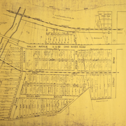
1977 Sciotoville Plat Map
Title
1977 Sciotoville Plat Map
Description
Browned, aged 1977 plat map of Sciotoville (Farney Maplewood & Sycamore Add's).
Bottom left hand corner indicates this map was revised in 11-77.
Bottom left hand corner indicates this map was revised in 11-77.
Creator
Unknown
Date
1977
Contributor
Map donated by Julia Basham
Format
28.8 x 22 inches map
Coverage
Sciotoville, Scioto County, Ohio
Rights
Portsmouth Public Library
Collection
Citation
Unknown, “1977 Sciotoville Plat Map ,” Local History Digital Collection, accessed May 3, 2024, https://www.yourppl.org/history/items/show/25623.

